Map of Venice Canals: 8 Key Insights for Italy and California
Searching for a map of Venice canals often leads to two very different destinations. Most visitors want the historic floating city in Italy — 150-plus waterways threading through 118 islands. A smaller group is looking for the quiet residential canals in Los Angeles, California. This guide covers both, but prioritises Venice, Italy, where navigating without a map is genuinely disorienting even in 2026.
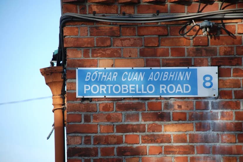
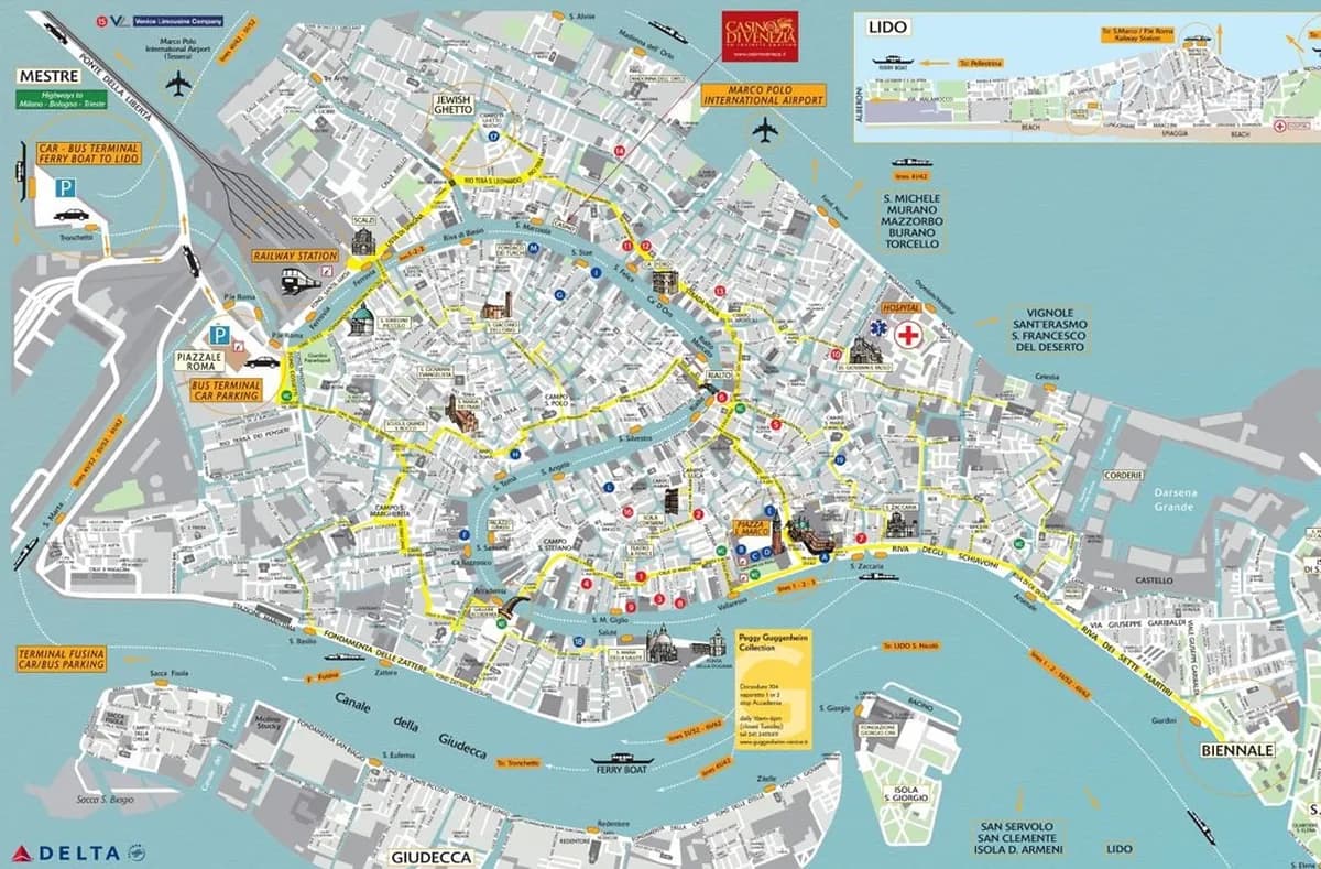
The Italian city is divided into six neighbourhoods called sestieri, each with its own canal network and character. Understanding this layout before you arrive transforms a confusing tangle of blue lines into a readable grid. If you are planning where to sleep, the best neighbourhoods to stay in Venice guide maps out each sestiere in plain terms.
The Six Sestieri: How Venice Is Actually Organised
Venice's historic centre is split into six administrative districts — known as sestieri — Cannaregio, Castello, Dorsoduro, San Marco, San Polo, and Santa Croce. Three sit on each side of the Grand Canal's S-curve. When you open any digital map, the sestiere boundaries are the first thing to orient by, not street names, which are notoriously hard to follow on foot.
San Marco sits at the eastern curve of the Grand Canal and contains the most-visited monuments: the Basilica, Doge's Palace, and the Rialto market area at its northern edge. Dorsoduro runs along the southern waterfront opposite the Giudecca island and has a quieter, student-district feel. Cannaregio stretches north from the train station toward the Jewish Ghetto and the Cannaregio Canal. Castello is the largest sestiere, extending east toward the Arsenale shipyard and the public gardens.
San Polo and Santa Croce share the northwestern bank of the Grand Canal. San Polo contains the Rialto market and the Frari church. Santa Croce borders the bus and car terminal at Piazzale Roma, making it the entry point for most travellers arriving overland. Knowing which sestiere a hotel, restaurant, or museum sits in cuts your map-reading time in half before you even leave home.
Navigating the Grand Canal and the Three Major Waterways
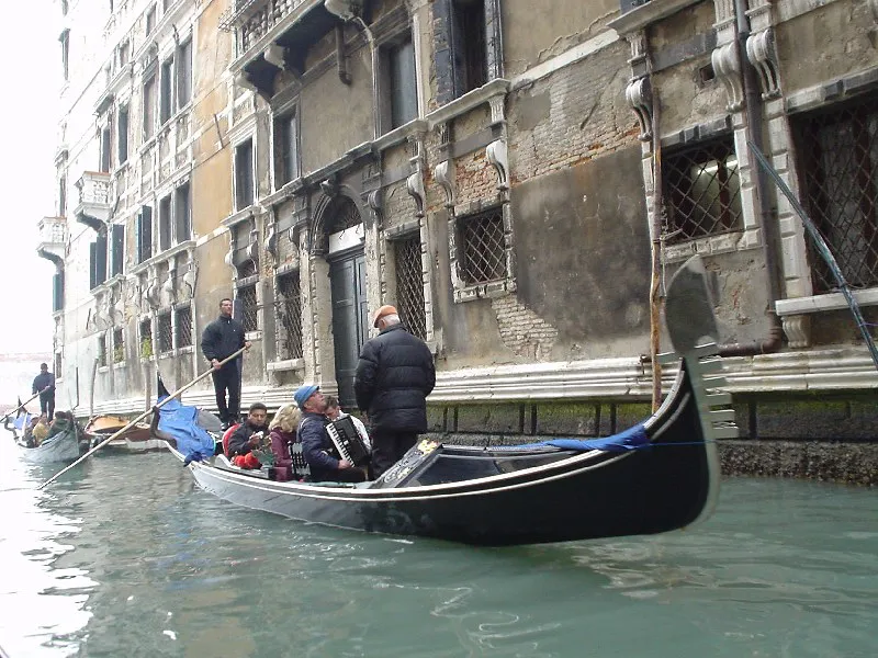
Venice has three named major canals that appear on every printed and digital map. The Grand Canal (Canal Grande) is the widest, roughly 30 to 90 metres across, forming an S-shape from Santa Lucia railway station to the San Marco basin. It divides the city's six sestieri and carries most of the commercial and tourist boat traffic. The Giudecca Canal runs along the southern edge of the historic centre, wide enough for cruise ships, separating the main island from the long thin island of Giudecca. The Cannaregio Canal connects the Grand Canal near the train station with the open lagoon to the north.
Public water buses (vaporetti) are the practical tool for using a canal map. Line 1 runs the full length of the Grand Canal stopping at every landing stage — the slow route, roughly 45 minutes end to end, and the best orientation ride for first-time visitors. Line 2 skips most stops and covers the same route in about 25 minutes. Both lines use the same stops; the difference is frequency of halting. A 75-minute single ticket costs EUR 9.50 in 2026; multi-day passes are cheaper if you plan more than two rides per day. Buy passes at the ACTV booths at major landing stages rather than from machines, which are slower during peak morning hours.
The Giudecca Canal is served by Line 2 and Line 4.1/4.2, which loop around the island of Giudecca. If your map shows an address on Giudecca itself, the Zitelle or Redentore landing stages are the closest disembarkation points.
The Four Bridges Crossing the Grand Canal
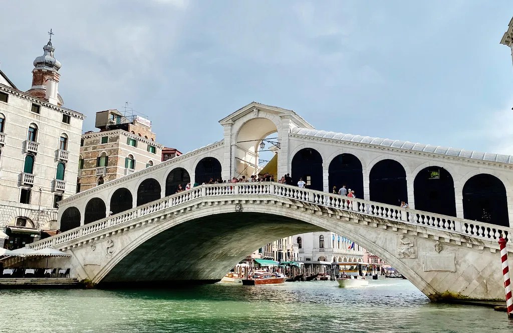
Only four bridges span the Grand Canal, and their positions are essential reference points on any Venice canal map. The Rialto Bridge (Ponte di Rialto) sits at the midpoint of the Grand Canal and is the oldest of the four, completed in 1591. It connects San Marco to San Polo and is flanked by the Rialto market, open Tuesday to Saturday mornings. The Accademia Bridge (Ponte dell'Accademia) is a wooden structure near the southern curve of the canal, linking Dorsoduro to the San Marco neighbourhood. It was built as a temporary structure in 1933 and has remained ever since.
The Scalzi Bridge (Ponte degli Scalzi) stands immediately outside Santa Lucia station, making it the first bridge most rail arrivals cross on foot. It was rebuilt in Istrian stone in 1934. The Constitution Bridge (Ponte della Costituzione), designed by Santiago Calatrava and opened in 2008, is the newest of the four, connecting Piazzale Roma (the road terminal) to the station area. It is controversial among locals for its glass steps, which can be slippery in wet weather and are inaccessible without the side ramp for wheelchair users.
If you are walking across the city, these four bridges are your crossing points. Between them you must either take a traghetto (a shared gondola ferry, EUR 2 per crossing at several informal points) or a vaporetto. Knowing which bridge is closest to your destination saves significant time, especially in the narrow lanes of San Polo and Santa Croce where signage is sparse.
| Bridge | Location | Built / Rebuilt | Connects |
|---|---|---|---|
| Rialto Bridge | Midpoint of Grand Canal | 1591 | San Marco ↔ San Polo |
| Accademia Bridge | Southern curve | 1933 (permanent) | Dorsoduro ↔ San Marco |
| Scalzi Bridge | Near Santa Lucia station | 1934 | Santa Croce ↔ Cannaregio |
| Constitution Bridge | Piazzale Roma area | 2008 | Piazzale Roma ↔ Station |
The 150 Rii: Reading the Side Canal Network
Most of the waterways in Venice are technically called rii (singular: rio) rather than canali. The distinction matters for map reading. On official Venetian maps and the stone address plaques mounted on buildings, a smaller waterway is labelled "Rio di Santa Maria Formosa" or "Rio di S. Toma," not "Canal." Only the three major waterways carry the canal designation. Knowing this prevents confusion when a narrow blue line on your screen shows a name that starts with "Rio" rather than "Canal."
These side canals are navigable by gondola and small service boats but not by full-size vaporetti. They are the reason Venice feels labyrinthine on foot — the rii create dead-ends where a street stops abruptly at the water's edge. The only way across is to backtrack to the nearest bridge. Digital maps with offline capability (Google Maps or Maps.me both work without a data connection once downloaded) show bridge locations clearly. Without offline access, you will find yourself backtracking more than expected in areas like Castello east of the Arsenale. You can find many hidden gems in Venice by following the quieter rii away from the main tourist corridors.
The Rio di S. Toma is a useful landmark in San Polo, running between the Rialto market area and the Frari church. It is identifiable on most maps because the Ponte San Toma crossing point is where walking routes from the Rialto to the Accademia bridge typically converge.
Venice Islands Map: Murano, Burano, and Torcello from the Lagoon
The secondary keyword "venice islands map" consistently pulls search traffic alongside canal queries because the lagoon islands require separate navigation planning. Murano sits about 1.5 km north of the historic centre and is served by Lines 4.1, 4.2, and 12 from Fondamente Nove — a 10 to 15 minute crossing. It has its own internal canal system with a main canal (Canal Grande di Murano) and a bridge connecting its two halves. The glass furnaces are concentrated along the main canal.

Burano is further north, roughly 9 km from the historic centre, reached by Line 12 from Fondamente Nove in about 45 minutes. The island is flat, small enough to walk end to end in 20 minutes, and famous for its painted fishermen's houses. Torcello is adjacent to Burano and the oldest settled island in the lagoon — the same Line 12 continues there. The Torcello guide covers what to see once you arrive. The Venetian lagoon islands guide maps all the islands together if you are planning a multi-island day.
On your vaporetto map, Fondamente Nove is the key northern departure point for all lagoon island lines. It sits at the top edge of Cannaregio. If you are staying in Cannaregio — the Cannaregio neighbourhood guide has the detail — you can walk to Fondamente Nove in under 10 minutes, which makes island day trips significantly easier than from San Marco.
Acqua Alta and How It Changes Your Walking Map
High tides (acqua alta) flood the lowest-lying areas of Venice several times each year, most commonly between October and January. When water levels reach 80–90 cm above mean sea level, Piazza San Marco floods first — it sits at the lowest point of the city. At 110 cm, large parts of the Rialto market area and Cannaregio waterfront go under. At 140 cm or above, the flooding affects most ground-floor streets across the centre. The MOSE mobile barrier system is now raised at the three lagoon inlets when tides above 110 cm are forecast, reducing — but not eliminating — flooding in the historic centre.
The city installs elevated wooden walkways (passerelle) on the main tourist routes during high-tide events, and a map of these routes is posted at major landing stages and online via the Centro Previsioni e Segnalazioni Maree website. The ACTV app and the "Venezia Unica" city mobility app both show real-time tide alerts in 2026. Checking these before you leave your accommodation in the morning is standard practice during autumn visits. If you are following a Venice free walking tour route during acqua alta, the passerelle routing changes the logical sequence of stops significantly.
One practical tip no map shows: the Dorsoduro and San Polo neighbourhoods sit slightly higher than San Marco and flood later. If your itinerary is flexible and tides are running high, shifting your morning to the Frari church or the Dorsoduro waterfront and saving San Marco for the afternoon (when tides typically recede) is the smartest routing adjustment.
During acqua alta events above 110 cm, Piazza San Marco floods first. Check the Centro Previsioni e Segnalazioni Maree forecast before 09:00 in autumn and winter — the MOSE barriers now reduce but do not eliminate flooding.
The Venice Beach Canal District: A Different Kind of Map
The Venice Canal Historic District in Los Angeles is a man-made network of six residential canals built by tobacco millionaire Abbot Kinney in 1905. He dug several miles of canals to drain the marshes and recreate Italian atmosphere for land buyers. By 1924 most were filled in to make roads. The four canals that survive today — Venice, Linnie, Howland, and Sherman, plus two smaller channels — are protected as a historic landmark and are strictly pedestrian in character. No motorised boats operate here.
The easiest walking entry is from 25th Avenue or Dell Avenue off Washington Boulevard, about a 10-minute walk south from the Venice Beach boardwalk. Parking is free in the public lot at the end of Venice Boulevard near the beach, though spaces fill by 10:00 on weekends. The full circuit of the walking paths takes about 45 minutes at a relaxed pace. Many visitors come for photography — the bridges and their reflections photograph well in the hour before sunset.
Practical Map Tips for Navigating Both Canal Cities
In Venice, Italy, download an offline map before you arrive. Mobile data inside narrow calli is unreliable and switching between apps while standing on a bridge with a water taxi bearing down on you is stressful. Google Maps offline covers the sestieri well. Alternatively, the free paper maps distributed at tourist information points near Santa Lucia station and Piazzale Roma show all four Grand Canal bridges, vaporetto stops, and the major rii clearly enough for a 2–3 day visit.
A 75-minute single vaporetto ticket costs EUR 9.50 in 2026; multi-day passes are cheaper if you plan more than two rides per day. Buy passes at the ACTV booths at major landing stages rather than from machines, which are slower during peak morning hours.
Younger travellers often find the waterfront near the Zattere promenade in Dorsoduro and the bacaro bars along the rii of San Polo easier to navigate once you have the Grand Canal as a spine reference. There are many things to do in Venice for young adults concentrated in these neighbourhoods. For food stops while you are map-walking, the best cicchetti in Venice are clustered in the narrow calli between the Rialto and San Polo — an area that rewards getting lost deliberately.
- Grand Canal crossings by foot: Rialto Bridge (central), Accademia Bridge (south), Scalzi Bridge (north, near station), Constitution Bridge (Piazzale Roma)
- Vaporetto for orientation: Line 1, 45 minutes end to end, stops at every landing stage on the Grand Canal
- Lagoon islands: all Lines from Fondamente Nove (north Cannaregio) — 15 min to Murano, 45 min to Burano
- Acqua Alta alerts: check Centro Previsioni e Segnalazioni Maree or the ACTV app before 09:00 in autumn
- Venice Beach, LA: enter via 25th Avenue, free lot at end of Venice Boulevard, 45-minute walking circuit
Frequently Asked Questions
Where are the Venice canals located in Los Angeles?
The Venice Canal Historic District is located in the Venice neighbourhood of Los Angeles. You can find the entrance near Washington Boulevard and Dell Avenue. It is just a short walk from the famous Venice Beach boardwalk and fishing pier.
How many canals are in Venice, Italy?
There are over 150 canals and rii weaving through the historic center of Venice, Italy. These waterways connect the 118 small islands that make up the city. You can view a full layout at Venice-Museum.com for detailed planning.
Can you walk along the canals in Venice Beach?
Yes, the Venice Beach canals feature public pedestrian sidewalks on both sides of the water. You can cross the canals using several charming footbridges throughout the district. Please respect the privacy of the residents while you enjoy the walking paths.
A map of Venice canals is most useful when you understand the structure behind it: six sestieri, three named major canals, four Grand Canal bridges, and a network of 150-plus rii that define how pedestrian movement actually works. Layer in the vaporetto lines and the lagoon island departures from Fondamente Nove, and the city becomes navigable rather than baffling. Download your offline map before you board the train or the plane, and check the tide forecast each morning in autumn. Whether you end up in Venice, Italy or Venice Beach, California, the water is the backbone of the place — understanding the layout before you arrive is the single best preparation you can make.