Tavolara and Molara Archipelago Guide: Boat Trips From Olbia
Plan a Tavolara and Molara boat day from Olbia: landing at Spalmatore di Terra, the Molara pools, marine park zones and which islands you cannot land on.
On this page
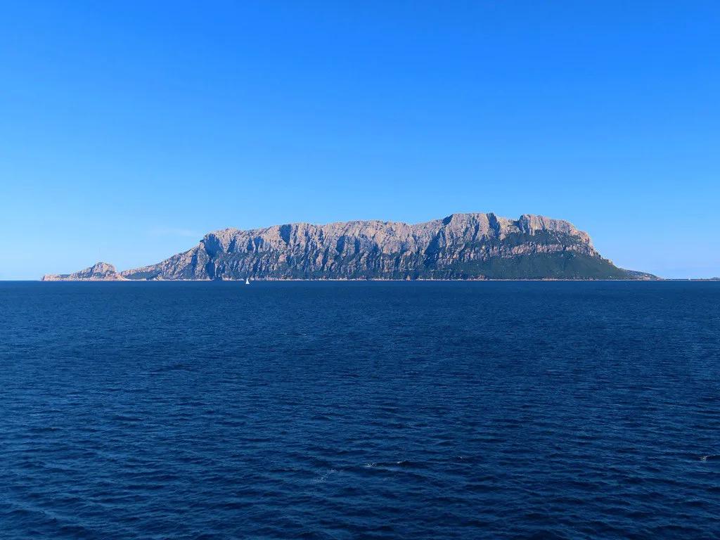
From the approach into Olbia you see it before you land: a pale block of rock standing almost vertically out of the sea, flat on top, entirely out of scale with the granite coast around it. That is Tavolara, and the archipelago it anchors with Molara and Molarotto is one of the most regulated stretches of water in Italy. A day here rewards planning, because the rules, not the map, decide where you can go.
This guide treats the day as a chain of decisions rather than a list of beaches: which boat, which landing point, which swim stops, and which areas you admire from a distance. Everything that changes season to season, including fees, buoy bookings and passenger caps, should be verified with the park authority before you commit. For the wider city, see our hidden gems in Olbia.
Why Tavolara Looks Nothing Like the Rest of Gallura
Almost all of Gallura is granite, and so are Molara and Molarotto. Tavolara is the exception: a limestone-dolomite massif resting at an angle on a granite base, which is why its walls rise so abruptly to the 565 metres of Punta Cannone across an island roughly six kilometres long and half a kilometre wide. Knowing this explains the shape you see from the plane and the ferry.
At either end sit two low, sandy peninsulas that look borrowed from another landscape, and only the western one matters to visitors. Spalmatore di Terra holds the beach, the landing stage, two restaurants and the homes of the island's long-standing family. The eastern peninsula toward Punta Timone hosts a NATO telecommunications base installed from the 1960s, with antennas and a partly tunnelled military road, and is a restricted zone.
Treat that geography as your first planning tool. Any itinerary implying you can wander Tavolara end to end is wrong; the visitable slice is a narrow western tongue with a beach behind it. Aim to spend your hours there or on the water, not on a walk that will be stopped by a boundary.
How Boats Reach the Islands From Olbia
For travellers without their own boat, the most direct route reported is the seasonal crossing from Porto San Paolo, the mainland gateway in the municipality of Loiri Porto San Paolo, landing directly at Spalmatore di Terra. A travel guide describes summer departures running roughly every half hour with a crossing of about twenty minutes, but treat that as an indication rather than a timetable and confirm current sailings with the operator before building a day around them.
Organised cruises add the swim stops that a plain ferry does not. One Olbia-area cruise product describes departure from Porto Ottiolu, a swim in the shallow water off Molara, free time on Tavolara and a lunch on board, with a route that also passes Cala Brandinchi. Departure ports, inclusions and cancellation terms vary a lot between operators, so read the specific listing rather than assuming any tour starts where you are staying.
A catamaran format appears in other listings, pairing the Tavolara and Molara circuit with lunch made from local Sardinian products and time over the protected seabed. If a leisurely pace and a served meal matter more to you than independence ashore, this is the shape to look for; if you want to walk the beach at your own rhythm, the plain crossing usually suits better.
With your own craft or a hired dinghy, you skip the ferry but inherit the paperwork. Mooring at buoy fields and jetties requires authorisation from the managing body, and places are limited enough that August bookings need to be made well ahead. Charter and passenger-transport operators should carry an authorisation sticker on the hull showing their name and number, which is a quick way to sanity-check your skipper.
What You Can Actually Visit on Tavolara
Ashore at Spalmatore di Terra the day is deliberately pared back, and that is part of its appeal. There is a sheltered beach with very shallow water, a small family cemetery behind a fence that takes minutes to see, and the vertical rock face to admire from below. The cemetery is where the Bertoleoni family rest, and guides call it the cemetery of the kings; it is not a monument, which is precisely why it stays with people.
Two restaurants on the island are run by the same family, and one source describes them as working by reservation in summer. Menus, opening patterns and whether booking is essential should be confirmed with the operator you intend to use rather than taken from any single article. Carrying water and a fallback picnic removes the risk entirely.
For walkers, a gentle loop trail of around thirty minutes crosses the island's lowland with displays on local flora and fauna, including Phoenician juniper, mastic trees and the Yelkouan shearwater colonies for which the island matters. The demanding ascent to Punta Cannone involves a technical via ferrata section, and the source stresses proper gear and an authorised alpine guide.
One caution applies to any summit plan: a climbing restriction was reported on the island after an accident on the via ferrata, with exceptions for qualified guides for educational and scientific purposes. Its current status is exactly the kind of rule that changes between seasons, so check with the municipality or an authorised guide before planning an ascent rather than relying on last year's information.
Molara and the Shallow Pools: What the Swim Stop Really Is
Molara is the granite island next door, uninhabited and privately owned, and it is not freely accessible. Visits happen only through a cultural association during limited periods between late spring and early autumn, so a boat that idles offshore is not offering you a landing unless the operator says so explicitly. The wildlife underpins the protection: peregrine falcon, Audouin's gull, European shag and hundreds of pairs of Yelkouan shearwater.
What everyone calls the Molara pools is not a formal lido but the stretch of very shallow, transparent sea between the island and the coast, and it is described as the busiest anchorage in the protected area. It is regulated with georeferenced points and length limits for vessels, which is why a small dinghy and a large yacht have different options. Swimming itself is unrestricted, so a tour stop here means clear water and plenty of company.
Timing changes the experience more than any other variable. The same source notes that tour boats move en masse mid-morning and stay in the main areas until late afternoon, so the same water at nine in the morning and at two in the afternoon feels like two different places. If you are chartering, ask your skipper to reach the pools early; if you are on a group tour, accept the crowd and enjoy the shallows for what they are.
Molarotto and Zone A: Look, Do Not Land
Molarotto, the pink granite islet a little further east, sits inside zone A, the strictest level of protection, where navigation and landing are prohibited according to the source, which also lists swimming and diving as barred there. It hosts seabird colonies dense enough to change the colour of the rock, dominated by European shag, plus an endemic lizard found nowhere else. No responsible operator will offer to put you ashore there.
Other zone A areas named in the same account include the southern tip of Cala di Levante on Tavolara, Punta del Papa and Punta del Passo Malo. These are not beaches with a soft boundary; they are strict nature reserve where you may not sail, anchor, swim or dive. Knowing the names matters when you are reading a boat itinerary or briefing a skipper, because an itinerary that lists them as stops is a red flag.
Marine Protected Area Rules in Plain Language
Some prohibitions apply everywhere in the Tavolara–Punta Coda Cavallo Marine Protected Area, regardless of zone. Jet skis and towed sports are banned throughout, anchoring on posidonia seagrass and coralligenous reef is forbidden so you drop anchor only on sand or pebbles, and spearfishing in any form is off limits. Untreated discharges and the collection of shells, sand and rocks are also prohibited, as is access to the dunes behind beaches.
In zones B and C you may sail, but slowly: five knots within three hundred metres of the coast and ten knots between three hundred and six hundred metres, always at displacement speed. Anchoring is allowed only on inert seabeds, with hull-length limits that differ between the two zones, and vessels over twenty-four metres need authorisation from the managing body even just to pass through to an anchorage.
Diving has its own regime. Independent diving without a guide is permitted only with prior authorisation, at named sites, within an afternoon slot, with at least second-level certification and in groups of six or fewer; guided dives go through authorised centres on provided moorings. Fees, site lists, buoy numbers and passenger caps sit in regulations valid for one year and updated each season, so any figure you read from a previous summer is likely out of date. Check the current provisions with the park authority before you set off.
None of this is bureaucratic noise: the posidonia meadows here are extensive and in good condition, groupers and brown meagre are protected even where recreational fishing is allowed, and the area holds the endangered ribbed Mediterranean limpet, from which the first laboratory-produced larvae of the species were obtained for a European restocking project. Following the rules is how you get to see any of it.
Plan the Day Backwards
The logic that avoids most mistakes is simple: start from the rules, not the places. First confirm what is permitted in the current season, because the regulations are annual and adaptive. Then look at the wind, which decides whether the exposed side of Tavolara is usable. Only then choose where to go, because those who pick a destination first regularly find their anchorage needs an authorisation they do not have, or that their boat is too long for the zone.
Shade is the underrated detail. Spalmatore di Terra is an exposed tongue of sand, and in the middle hours of July and August there is no shelter at all. Early morning or late afternoon is the better stop, when the limestone face also changes colour. Building the day around that means the beach, not the boat schedule, sets your rhythm.
There are no services on the smaller islands: no kiosks, no refuelling and no guaranteed shade, so water, sun protection and a lunch plan must be sorted on land before departure. The wider protected area runs for roughly forty kilometres from Capo Ceraso past San Teodoro, and guided boat trips or the crossing from Porto San Paolo are the standard ways in for visitors based in Olbia.
If you are choosing between a group cruise and doing it yourself, weigh control against effort. A crewed boat handles authorisations, moorings and timing, and the sticker on the hull tells you the operator is authorised; a self-charter day gives you the empty early-morning pools but puts the regulation reading on you. Neither is better, but they demand different preparation.
The Kingdom Story: What Is Documented and What Is Tradition
Tavolara is introduced everywhere as the smallest kingdom in the world, with a dynasty of shepherd kings recognised by the House of Savoy and photographed at Buckingham Palace. The documented part is narrower: Giuseppe Bertoleoni, born in La Maddalena in 1778, settled on the island in the early nineteenth century to raise goats and built its first stone house, and his descendants followed one another there across generations and are still present today.
The rest belongs to family tradition. No deed survives for the 1836 visit of Charles Albert of Savoy or the granting of a royal title, the investiture parchment is said to have been lost, and the Bertoleoni do not appear in any Italian register of nobility. Tavolara is Italian territory in the municipality of Olbia without legal ambiguity, so tell the story as tradition rather than record, and skip the golden-toothed goats, which remain unconfirmed.
Suggested Shapes for a Half Day and a Full Day
For a half day, our suggestion is the crossing to Spalmatore di Terra, an hour or two on the beach and around the lowland loop, and the return boat, with the caveat that sailings and frequencies must be confirmed for your dates. This suits travellers who mainly want to stand beneath the rock face and swim from a sheltered shore.
A full day works better for combining a landing with time on the water. In our suggested shape, you take an early crossing or an early charter slot to reach the Molara shallows before the fleet arrives, land at Spalmatore around midday or late afternoon when the light softens, and keep one eye on the wind forecast. Group cruises that fold in lunch and several swim stops compress this into a single booking.
For the culture-and-coast side of Olbia between boat days, our Olbia Attractions hub covers the museums and churches within the city. It pairs naturally with a marine day, since the archaeology of the ancient port explains why this harbour has mattered for two thousand years.
Plan Your Visit
Tavolara and Molara reward travellers who arrive informed rather than surprised. Book the crossing or the cruise, read the zoning once, ask the operator what authorisations they hold, and check the current annual regulations with the park authority before you travel, because fees, buoy fields and diving provisions are reviewed each season.
Base yourself in Olbia, where the airport, the port and year-round town life make a boat day easy to slot between other plans. SardegnaTurismo lists the island's events and sites by month if you want to time the trip around something else, and the town itself deserves at least an afternoon before you head for the water.
Frequently Asked Questions
Can you land on Molara?
Molara is uninhabited and privately owned, and it is not freely accessible. Visits are organised only through a cultural association during limited periods between late spring and early autumn. Most boat trips that mention Molara are stopping in the shallow water offshore for a swim, not putting passengers ashore, so confirm the itinerary with your operator before booking.
Do you need a permit to sail through the Tavolara marine protected area?
According to the account summarised here, a small craft or vessel under twenty-four metres simply sailing in zones B or C requires no authorisation as long as you respect the speed limits and the general prohibitions. You do need authorisation from the managing body to moor at buoy fields and jetties, and larger vessels need clearance even to pass through to an anchorage. Rules are updated each season, so check current provisions with the park authority.
How do you get to Tavolara without a boat?
The usual route is the seasonal crossing from Porto San Paolo, which lands at Spalmatore di Terra. Reported summer frequencies of roughly every half hour and a crossing of about twenty minutes should be treated as an indication rather than a timetable, so confirm sailings with the operator for your dates. Organised cruises also call at the island, some departing from other ports along the coast.
Is the Tavolara summit climb open?
That status cannot be assumed. A climbing restriction was reported following an accident on the via ferrata, with exceptions for qualified guides for educational and scientific purposes. Because this is exactly the kind of rule that changes between seasons, check with the municipality of Olbia or an authorised alpine guide before planning any ascent.
What is banned everywhere in the marine protected area?
Jet skis and towed sports are prohibited throughout the area without exception, as are anchoring on posidonia and coralligenous reef, spearfishing in any form, untreated discharges, and collecting shells, sand or rocks. Access to the dunes behind beaches is also forbidden. These apply in every zone, not just the strictest one.
Are there restaurants and services on Tavolara?
Ashore at Spalmatore di Terra there are two restaurants run by the island's family, described in the source as working by reservation in summer, plus the beach and the landing stage. Services are minimal and the smaller islands have none at all, so bring water, sun protection and a lunch plan from the mainland. Confirm current restaurant arrangements directly before relying on them.
Sources
- SardegnaTurismo - Sito ufficiale del turismo della Regione Sardegna
- Tavolara & Molara Island Cruise | musement
- Tavolara Island: best beaches and travel guide - The Wom Travel
- Tavolara and Molara: the archipelago almost nobody sails - goldencoast.it
- Island of Tavolara, Maddalena Islands and Gulf of Orosei - Borgo di Campagna
- Tavolara and Molara: Full-Day Catamaran Cruise with Lunch and Dolphins | Trip.com
- Official event website
Continue exploring
More guides you'll find useful